Track

Automated recording of GPS location, spray width, weather, chemical amount and type from one or many spray sections.
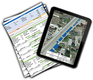
Map

Applicators monitor progress from their mobile device while administrators view real-time status of every applicator from the office.
Report

Automated sync and detailed reporting for customer invoicing, regulatory reporting and liability protection. Instantly available for printing.
Share

Export spray data to Google Earth or any GIS system using shapefile, KMZ, GPX. Optional API and WFS service for advanced GIS integration.
Spray Mapping and Reporting Simplified
SprayLogger powered by ActionMapper is a complete, automated spray tracking system. Quickly retrofitted on absolutely any spray rig, SprayLogger generates live, moving maps that both applicators and office personnel can follow in real-time.
At the end of each application, SprayLogger automatically generates detailed, printable reports designed to meet all state and federal application reporting requirements. SprayLogger is simply the easiest way to generate professional application maps and reports without changing the way you spray.
SprayLogger for ROW Trucks and Hy-rail
SprayLogger is powerful enough to capture every spray detail from the largest rigs with the most complex setups. The multi-port tracking system allows applicators to independently track up to 12 different spray sections and 4 flow sensors. Powered by the ActionMapper S12, SprayLogger can track precision quantity applied measurements on both injection systems and from tank mixes. Applicators can even switch between tank mixes quickly without altering SprayLogger’s tracking. Whether you need to track and map a single flow line or multiple spray sections and nozzles, SprayLogger handles it.


SprayLogger for ATV/UTV
If all you need to know is where you sprayed and where you didn’t, SprayLogger can do that, too. Streamlined for rigs with 3 or fewer boom sections, the ActionMapper S3 is a perfect fit to power SprayLogger for ATV and UTV spray rigs.
SprayLogger for Backpacks
AgTerra introduced the ActionMapper Mini to bring SprayLogger precision to the backcountry. ActionMapper Mini records low-flow applications without sacrificing accuracy. The light-weight system is designed to work in the most remote areas. The compact datalogger gives you powerful, precision spray tacking without the need for a flow sensor. For single nozzle applications in locations not easily accessed by vehicles, ActionMapper Mini and SprayLogger on your mobile device keep your data flowing.

A Professional Image Makes All the Difference
 SprayLogger enables you to exceed customer expectations by delivering professional maps and reports for your spray jobs with very little effort. Automation unlocks efficiencies in your operation. SprayLogger takes the hassle out of measuring important variables such as chemical usage, costs and weather data while also managing workflow and personnel. SprayLogger adds value to any spray operation. AgTerra’s system generates detailed reporting with a wide array additional of features:
- Map spray and no-spray applications for every spray job in real time.
- Capture details including the exact amount of active ingredient applied.
- Log spray width and location for tanks, sections, nozzles, and even hose reels.
- Filter and report by date, target pests, chemical, customer, applicator and spray rig.
- Export to database or GIS formats including CSV, KMZ and SHP for use in third-party systems such as Google Earth and ArcGIS.
- Use with low volume, high volume and variable rate applications on a wide variety of sprayers, inlcuding UTV, truck, hy-rail, watercraft, foggers and backpacks.
- Create monthly and yearly detailed summary reports for every job showing total gallons, acres, chemicals used, and more for every customer.
- Generate professional reports with a business logo, complete application details, time, costs, detailed weather, applicators, signatures and a spray map.
Go Beyond the Spray Lines
SprayLogger is a plugin to MapItFast, which gives you access to AgTerra’s complete line of mapping and data gathering tools. Create custom forms, and attach them to any map object. Simultaneously map points, lines, polygons and geophotos using GPS or hand drawing without interrupting spray tracking. Even further, authorized users have access to MapItFast Web, where they can view spray activity of other users in real-time.
In addition to tracking and reporting on pesticide application, vegetation management professionals use MapItFast and Strider to record weed inventories, dispatch crews to new job assignments, document field observations and much more.
Start a Job and Spray
The SprayLogger “Fast Start” menu lets spray applicators start a job by answering 1-5 simple questions on their Android mobile device. From there SprayLogger does the rest. Combined with automatic cloud syncing, your projects will be available for printing when you pull into the shop.
No more paper reports to fill out by hand. You simply download your automatically generated reports and maps from your online account. Your customers get the detailed reports they demand. You save time and get more jobs.
Spray away. A long way away!
Whether that job in the backcountry has you on a hose reel or a backpack, SprayLogger stores data and maps every application on your device until you re-establish a data connection. Then, everything is automatically uploaded to your private account. Automated spray tracking means there is no manual data transfer required.

Keep Spraying and Leave the Reporting to Us
More spray time, less desk time, isn’t just a catchy saying. AgTerra understands that spray applicators have limited time to get their jobs done each season. They can’t be dedicating any of those hours to collecting data and writing up reports for regulators. We developed SprayLogger to keep you spraying and reduce the time it takes to create maps and reports. SprayLogger automates your data gathering and reporting tasks, generating the detailed reports your customers expect without the errors of pen and paper entry. By including printable reports of every application on automatically generated emails, you can improve efficiency in your weed control and vegetation management operations and focus on spraying.
Get the most advanced pesticide record keeping system on the market.
Call AgTerra TODAY to get started at (307) 673-1050.
For well over a decade AgTerra has enabled natural resource professionals to simplify data collection and reporting while delivering greater value to their customers. How can we help you? Contact us today and let us help you learn how easy and affordable our technology can be for your workforce and operations.
